 Famed for their rich and diverse ecosystems, and consequently for the role they played in helping Charles Darwin form his theory of evolution, the Galapagos Islands have fascinated biologists, researchers and nature enthusiasts the world over.
Their relatively isolated location hundreds of miles off the west coast of Ecuador means they’re not the easiest place to get to, or the cheapest, for that matter.
With Google seemingly intent on mapping every square inch of the planet, it was only a matter of time before it got its panoramic camera gear in among the islands’ flora and fauna, a move that will soon allow anyone with an Internet connection to explore the area’s rich biodiversity from the comfort of their own living room.
In a post on its LatLong blog on Thursday, Google Maps project lead Raleigh Seamster revealed that a team of photographers have been working in the Galapagos Islands collecting panoramic imagery for its Street View site, with the fruits of their labor set to be rolled out later in the year.
The project was made possible thanks to a partnership with the Charles Darwin Foundation (CDF) and the Galapagos National Parks Directorate (GNPD).

“It’s critical that we share images with the world of this place in order to continue to study and preserve the islands’ unique biodiversity,” Seamster wrote in the post.
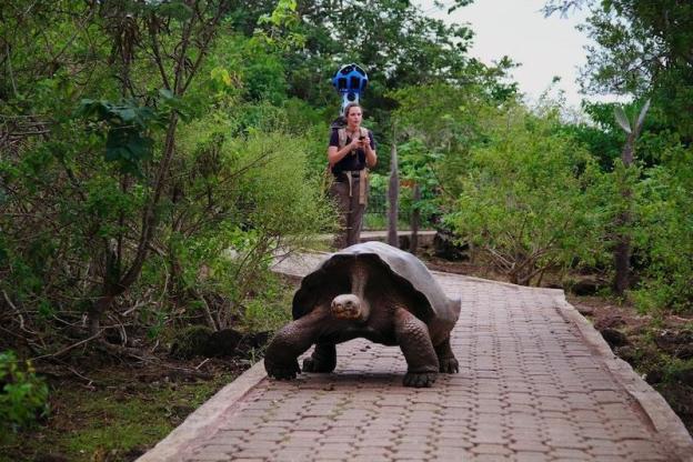
The team spent 10 days on the islands, hiking, boating and diving. Sounds like fun, but don’t forget, they were lugging around a pretty hefty camera-equipped backpack – dubbed the Trekker – as they went about their task.
The Trekker is used for locations its camera-laden cars, trikes, trolleys and snowmobiles are unable to access – such as the Grand Canyon, where the Trekker was first put through its paces.
This body-based camera is operated by an Android device and comprises 15 lenses positioned at various angles, allowing for the images to be stitched together to create the familiar 360-degree panoramic views we see on Street View. The Trekker snaps photos once every every 2.5 seconds.

“We walked past giant tortoises and blue-footed boobies, navigated through steep trails and lava fields, and picked our way down the crater of an active volcano called Sierra Negra,” Seamster wrote.
Underwater shots taken around the islands will also be coming to Street View, images made possible thanks to help from the the Catlin Seaview Survey. This is the second time Google has teamed up with the Catlin Seaview Survey – last year the pair worked together to map Australia’s Great Barrier Reef.
Besides allowing nature enthusiasts to marvel at the wonder of the Galapagos Islands from anywhere in the world, the gathered data will also help scientists to analyse and evaluate the changing condition of the islands and their marine environment.
“We hope this Street View imagery not only advances the important scientific research, but also inspires you to learn more about this special place,” Seamster said, adding, “We can’t wait to share this amazing imagery with you later this year.”


