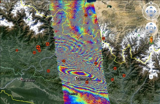
Scientists from NASA, the Advanced Rapid Imaging and Analysis project and the California Institute of Technology have analyzed interferometric synthetic aperture radar images of the earthquake location. Additionally, a new downloadable KMZ file is available for the public to view the region via Google Earth, according to GEarthBlog.com.
The map shows that the ground moved upward with the maximum movement point located slightly north of Kathmandu. The imagery is now available for free to emergency responders under a public license, courtesy of DigitalGlobe. Maps that depict damaged areas are also being provided to encourage volunteers to visit specific locations where help is needed.
The radar images analyzed by the scientists came from the PALSAR-2 instrument on the ALOS-2 satellite. The satellite, which is operated by the Japan Aerospace Exploration Agency, has the ability to calculate the deformation of the Earth’s surface from space.
Images show that the ground moved up by 4.6 feet around Kathmandu. This earthquake was the largest since the 1934 Nepal quake that had a magnitude of 8.0.
Google Earth is not the search engine giant’s only tool playing a role in the Nepal earthquake recovery efforts. Recently, Google announced that it would be opening its Person Finder tool to support rescue efforts, according to The Verge. The Person Finder tool is Google’s missing persons database, and it is open source. It was notably used after the earthquake that hit Haiti in 2010.
In addition to providing valuable geologic information, Google Earth has provided more somber images in recent weeks as well. Satellite pictures from Google Earth that were released on April 28 showed sprawling tent cities across Kathmandu, according to The Huffington Post.


