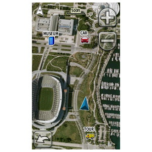
GPS maker Garmin ha announce it plans to launch a new BirdsEye satellite and serial imager service for its Oregon, Dakota, and Colorado series of outdoor navigation devices. The serve will put highly-detailed geo-referenced photo-based maps into the devices, enabling users to see actual buildings, cartography, roads, terrain, rivers, features, with GPS features like points of interest and programmed routes laid over the top of the images.
Garmin says the images from DigitalGlobe are among the most detailed available on the market—showing details down to half a meter across—and users can set zoom levels so their screens show everything from 20 miles to 12 feet at a time. Users will also be able to put vector maps on top of the photo maps, giving a clearer idea of terrain and points of interest.

“Without a doubt, BirdsEye Satellite Imagery reinforces Garmin as the leader in outdoor cartography,” said Garmin worldwide sales VP Dan Bartel, in a statement. “Whatever the occasion, outdoor explorers can find the ideal Garmin handheld and accompanying maps to complement their specific requirements.”
The service will launch in March 2010 for $29.99 per year, and users will need to use Garmin’s free BaseCamp software (available for PCs and Macs) to transfer BirdsEye data to their devices. Users can also connect their Garmin device to their computer and browse the BirdsEye imagery on their computer.


