NASA successfully tests a drone traffic control system

NASA system monitors drone flights
NASA Ames Research Center
NASA has been working on a UAS traffic management (UTM) system to handle the growing number of unmanned aerial vehicles taking to the skies. On Tuesday the system successfully underwent its largest test to date, a NASA spokesman told Digital Trends, with remote flights at all six FAA test sites this week.

As part of the testing, drone operators at each site simultaneously flew a variety of remote-controlled unmanned aircraft systems. The test sites are dispersed across the country and included locations in Alaska, North Dakota, Nevada, New York, Virginia, and Maryland. At one point, a whopping 24 drones took to the air at the same time during this early stage of testing.

Recommended Videos

Success! 24 #drones in the air for a great test of the UTM research platform! https://t.co/bpxHbOuKmi #nasaaero pic.twitter.com/RjrALUpY3U

— NASA Ames (@NASAAmes) April 19, 2016

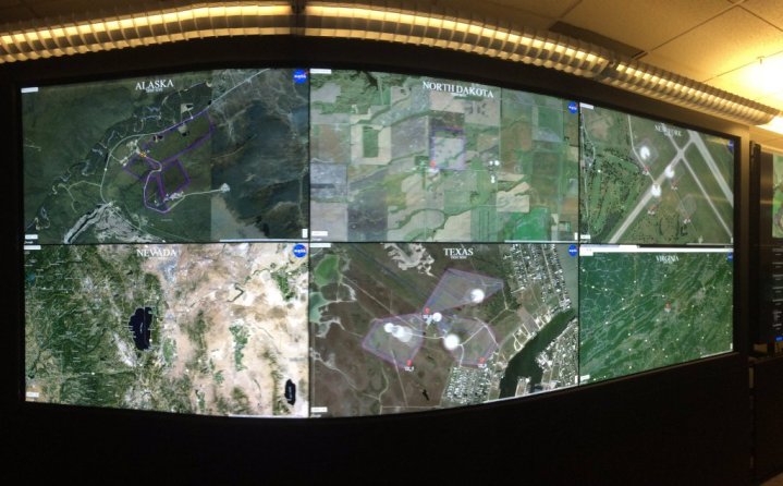
To hit that number, each test site flew up to four drones at a time while interacting with the UTM system during all stages of the flight. Before flying, each drone operator entered a flight plan into the UTM system, which checked the proposed path for potential conflicts and either approved or rejected the flight. Operators were notified of their approval status before their scheduled flight time. Once in the air, the drone’s flight pattern was tracked by the UTM both on a local and a national level — leading to the amazing image atop this article. Not only were the flights tracked at each FAA test site,  each drone also was monitored remotely by engineers working at NASA’s Ames Research Center in Moffett Field, California.

These tests were a milestone for the system — it’s the first time the UTM research platform was tested at all six FAA sites at the same time. It was the largest live test with 24 simultaneous live flights and the first time both live and simulated flights have been processed by the platform. It was also the first time controllers at each location tested the NASA-developed UTM displays and apps on a live flight. NASA hopes to use information gathered from these tests to refine the system so it can track different types of unmanned aircraft and a greater number of them flying in geographically diverse locations.

Updated on 04-21-2016 by Jeremy Kaplan: Corrected the headline to show that the FAA is not involved in testing, but has agreed to allow NASA to use its test sites, and to reflect successful completion of the test.

Kelly Hodgkins
Kelly's been writing online for ten years, working at Gizmodo, TUAW, and BGR among others. Living near the White Mountains of…
Why the moon needs a space traffic control system
astronomers using the NASA/ESA Hubble Space Telescope have measured the amount of ozone in Earth’s atmosphere

“Magnificent desolation.”

Those were the words used by Buzz Aldrin to describe the vast emptiness of the lunar landscape prior to stepping onto its surface for the first time in July 1969. But what if the moon – or, rather, its orbit – wasn’t so desolate after all? What if it was more akin to, say, the gridlocked traffic of a rush hour Los Angeles commute? What if indeed?

Read more
Drone pilots face hefty fine if they fly near the Super Bowl
DJI Mavic 2 Pro

Drone pilots have been warned to keep their flying machines well away from SoFi Stadium in Inglewood, California, during Super Bowl 2022 or face a hefty fine of at least $30,000 and potential criminal prosecution. On top of that, drones spotted within the designated no-fly zone could be knocked out of the sky with “deadly force,” according to a flight advisory from the Federal Aviation Administration (FAA).

A temporary flight restriction will be in effect from 2:30 p.m. through 8:30 p.m. PT during the big game on Sunday, February 13. The flight ban covers a 30-nautical-mile radius of the stadium and extends 18,000 feet skyward.

Read more
NASA plans to use drones to monitor active volcanoes
View of the Makushin Volcano summit captured by a camera on the wing of the S2 aircraft. The unmanned aircraft system flew autonomously beyond range of its pilot’s sight – 15 miles away and to an altitude of 6,000 feet – to capture data about volcanic activity during a flight demonstration in September 2021.

NASA doesn't only work on space projects: The agency also takes part in Earth-monitoring projects, particularly those related to the climate. Currently, it is working on a plan to use drones to monitor active volcanoes and give warnings of potential eruptions.

NASA is collaborating with the company Black Swift Technologies, which creates highly rugged drones of unmanned aircraft systems (UASs) which can withstand the tough environments above volcanoes. “We needed it to be really rugged, to withstand flying in the turbulent conditions and corrosive gases around volcanoes,” said Florian Schwandner, director of the Earth Sciences division at NASA Ames in a statement. “We also developed a gas-sensing payload the UAS could carry to look for signs of volcanic unrest.”

Read more