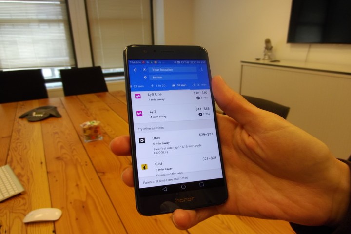
Google Maps gains Lyft and Gett ridesharing integration

google maps lyft gett hb4116
Image used with permission by copyright holder
If you fall into the all-too-common category of phone users who traipse around glued to Google Maps, then you’re probably familiar with the app’s ridesharing integration. Basically, when you’re figuring out a way to get from point A to point B, a tab in Google Maps provides an ETA and estimated fare for on-demand services like Uber.

The problem is, other apps have traditionally been left out: eschewing Uber for Juno, Fare, or Fasten required hopping out of Maps for a spell. But that’s finally changing, at least for some services. On Thursday, Google announced the addition of Lyft and Gett to the ride-hailing tab in Maps.

Recommended Videos

Maps’ ridesharing tab was added earlier this year, in March, and it’s relatively straightforward. Navigate to a place — the Empire State Building, say, or the Golden Gate Bridge — and alongside turn-by-turn walking, biking, driving, and public transit directions, you’ll see a ridesharing tab. It shows a comparison of services broken down by the tiers each offers —  for example, estimated fares for both UberX, Uber’s low-cost option, and UberXL and UberBLACK, its luxury alternatives. And you’ll see estimates for the amount of time you’ll have to spend stuck in traffic.

Starting today, Lyft and Gett’s myriad of ridesharing options will join Uber’s in Maps. Install Gett and Lyft on your phone and, depending on your geographic location, shortcuts for Lyft, Lyft Line, and Lyft Plus will begin appearing alongside the familiar Uber tiers. Google said the integrations will roll out in the iOS and Android Maps app over the coming weeks.

Lyft and Gett aren’t the first non-Uber ridesharing apps to join Maps. Earlier this year, the search giant added 99Taxis in Brazil, Ola Cabs in India, Hailo and Gett in the U.K., and Mytaxi in Germany and Spain. Today’s additions bring the total to nine across 60 countries.

These changes come hot on the heels of Maps improvements major and minor. Google introduced Lists in August, a feature which lets you organize places you’ve visited by collection (“Favorites,” “Want to go,” and “Share place”), and evidence in beta releases of Google Maps point to more significant enhancements coming. Maps might gain speed limits in driving directions, for one, plus improved integration with food delivery services like Gruhub, Eat24, and Delivery.com. And in the coming months, an (as-yet unfinished) feature might alert you of nearby available parking.

Kyle Wiggers
Former Digital Trends Contributor
Kyle Wiggers is a writer, Web designer, and podcaster with an acute interest in all things tech. When not reviewing gadgets…
Google gives Maps’ Immersive View a boost and adds a new vibe feature
An aerial view of London on Google Maps.

Google is continuing its never-ending work of enhancing Maps, with four new updates coming to the app on Wednesday.

First up, the team has been working to expand the coverage of Immersive View. Google started rolling out the feature in July, offering remarkably detailed 3D fly-arounds of famous landmarks and layering it with useful information such as the weather, traffic conditions, and the general busyness of the area. It can do this for the current time or, by examining historical trends, for a future date. Immersive View will also let you zoom in from an aerial view right into, say, a restaurant of interest, at which point the software flips to Street View in order to take you right inside, if the imagery is available.

Read more
Google Maps rolls out fly-around imagery of top landmarks
An aerial view of London on Google Maps.

Unveiled at its I/O event earlier this year, Google is now rolling out a cool feature for Maps that offers 3D fly-around views of famous landmarks.

The new Immersive Views feature is available for both iOS and Android and offers highly detailed aerial views of well-known places such as London’s Big Ben, New York City’s Empire State Building, and Tokyo’s Skytree.

Read more
What Google Maps can tell us about the Russian invasion
what google maps can tell us about the russian invasion russia starts large scale attack on ukraine

Russia’s invasion of Ukraine may be the first major military conflict that can be tracked live on Google Maps. 

What appeared to be armored vehicles were visible on Wednesday from a Google traffic jam update, arms control expert Jeffrey Lewis noted in a tweet. Experts say it's a sign of the challenges militaries face when trying to move covertly in an age of ubiquitous surveillance. 

Read more