Google lets you explore Rio Olympic venues with ‘enhanced’ maps

google maps rio olympics
Google
Besides plenty of local visitors, the International Olympic Committee predicts at least half a million people from overseas will descend on Rio de Janeiro for the Games in August.

No doubt lots of them will be carrying smartphones, probably loaded with Google Maps, an app certain to be indispensable in the new and busy surroundings.

Google
olympics indoors
Image used with permission by copyright holder

The Mountain View company is keen to make its maps offering as useful as possible for those heading to the Olympics, this week rolling out updated maps for 25 official indoor venues as well as enhanced maps for 12 official outdoor venues for the Games. The new content comes just a few weeks after the app introduced real-time transit information for the Brazilian host city.

Recommended Videos

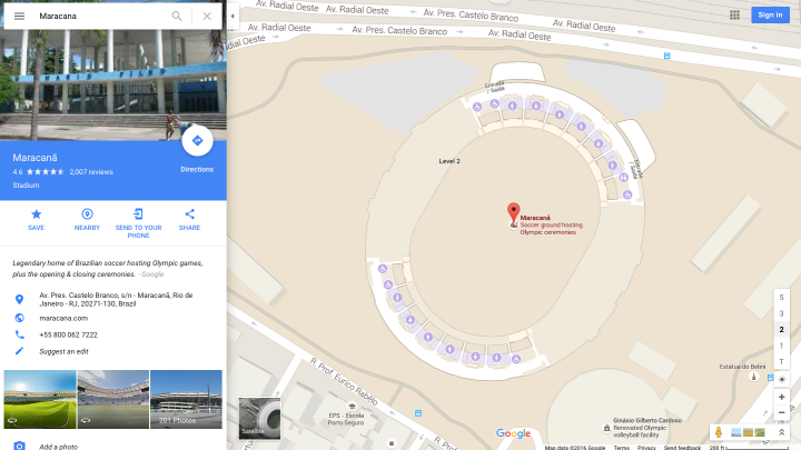
To access the new content, open Google Maps on your computer or mobile device, search for an Olympic venue, zoom into it and then click or tap on it.

At the bottom right side of the display you’ll see numbers for each floor of the building – tap on these to access each level’s map, which’ll highlight information for things like concessions, restrooms, information desks, and ATM machines.

Google offers up a few examples that you can check out right now – there’s the Maracanã Stadium, for example, where the opening and closing ceremonies will take place, and the 18-hole golf course south-west of the city, which’ll host the first Olympic tee-offs in 112 years.

Planning to watch the sporting extravaganza from the comfort of your sofa instead of heading to South America? In that case, Google suggests you use its new content to “daydream about an Olympic getaway,” exploring the venue maps on your smartphone when they show up on the TV during the Olympic events. Think of it as an extremely watered-down virtual reality experience.

Trevor Mogg
Contributing Editor
Not so many moons ago, Trevor moved from one tea-loving island nation that drives on the left (Britain) to another (Japan)…
Google now lets you know the best time to book a cheap flight
facial recognition

The latest version of Google Flights provides you with new information designed to help you make a more informed choice about when to book a ticket for a flight.

“Most of the time, it’s better to book on the early side, especially when your plans aren’t very flexible,” Google Flights’ James Byers says in a blog post introducing the new features. “But flight prices do change frequently, and there are often low fares to be found with the right tools (and some perseverance).”

Read more
Google Maps adds a nifty new feature to Immersive View
A screenshot from Google Maps for routes.

Google Maps has boosted its Immersive View feature with a new element that lets you explore a planned route in a whole new way.

Announced on Wednesday at its annual I/O event that also introduced a bunch of cool new devices, Immersive View for routes lets you see every segment of your trip before you set off, whether you're driving, walking, or cycling.

Read more
Google gives Maps’ Immersive View a boost and adds a new vibe feature
An aerial view of London on Google Maps.

Google is continuing its never-ending work of enhancing Maps, with four new updates coming to the app on Wednesday.

First up, the team has been working to expand the coverage of Immersive View. Google started rolling out the feature in July, offering remarkably detailed 3D fly-arounds of famous landmarks and layering it with useful information such as the weather, traffic conditions, and the general busyness of the area. It can do this for the current time or, by examining historical trends, for a future date. Immersive View will also let you zoom in from an aerial view right into, say, a restaurant of interest, at which point the software flips to Street View in order to take you right inside, if the imagery is available.

Read more