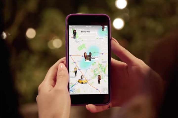
Snapchat’s new Snap Map will show you where your friends are

Snapchat Snap Map
Image used with permission by copyright holder
It is no secret that Snapchat has been hit hard with strong competition from Facebook-owned Instagram over the past year, but the social media company is not taking it lying down. On Wednesday, it announced its newest feature addition — Snap Map.

The new location-based Snap Map is Snapchat’s way of trying to help users see what is going on around them with other users and events. The feature also gives users a new way to follow their friends, with not only what they are snapping on their own, but what others are snapping at that location as well. It is a move that Snapchat is hoping will strengthen the community and help make connecting with old and new friends on the service easier.

Introducing Snap Map

You would not be out of place to be wondering about your privacy with this feature, but don’t worry privacy warriors, you can turn on a “Ghost Mode,” which hides your location from your friends and prevents you from showing up on the map. Snapchat made it clear that this feature will help you connect with friends and those around you, but only if you want it to.

Recommended Videos

If you decide to opt-in and allow Snap Map to share your location data, then your Actionmoji will appear on the map. Other users will then be able to see your snaps and the snaps of others at that location.

Accessing the Snap Map is easy as well, Snapchat added the map as a new layer over the current Snapchat experience. All you have to do to open and view the map is pinch to zoom from the Snapchat camera. The first time that you open the Snap Map you will be taken through a little tutorial that explains the feature and how to use it.

The Snap Map feature is already available for both iOS and Android users with a new update that is currently rolling out across both platforms. If you would like to check out the new Snap Map feature, all you need to do is update your app once the update becomes available to you.

Anthony Thurston
Former Digital Trends Contributor
Anthony is an internationally published photographer based in the beautiful Pacific Northwest. Specializing primarily in…
Google Maps will now show coronavirus outbreaks in your area
man checking phone with mask on

Google Maps’ latest update shows if an area is experiencing a coronavirus outbreak or not. 

The “COVID Layer” in Maps shows how many new confirmed coronavirus cases there have been the last seven days in a specific region using color-coding, with red representing a spike in cases. The tool shows the average of new coronavirus cases per 100,000 people and works in 220 countries and territories. 

Read more
Google Maps reminds you to wear a mask in new update
man checking phone with mask on

If you’re looking for a restaurant or coffee shop to go to, Google Maps now reminds you to wear your mask before leaving your house.

A new banner that says, “Wear a Mask. Save Lives.” now appears on your Maps’ “Explore” tab if you're using an Android phone. 

Read more
Facebook map shows you where people are reporting coronavirus symptoms
Facebook has an interactive map tracking people who say they are exhibiting coronavirus symptoms across the U.S.

Facebook has posted an interactive map that tracks where people are self-reporting symptoms of coronavirus, officially known as COVID-19, by county.

The map pulls data from a survey of Facebook users who self-reported symptoms to researchers from Carnegie Mellon University. Scientists say the information could be used to predict where coronavirus outbreaks will hit next.
What is the purpose of the map?
The map could help give public health officials and governments a clearer picture of the spread of the disease and might aid them in trying to decide when and how to reopen the communities.

Read more