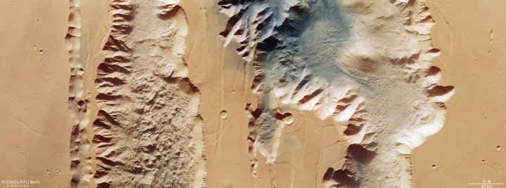
The sights of Mars are many and marvelous — and the European Space Agency (ESA)’s Mars Express orbiter recently captured one of the planet’s wonders, the Valles Marineris canyon system.
This enormous canyon system is nearly 2,500 miles long and over 120 miles wide, and is more than 4 miles deep in places. That makes it 20 times wider and five times deeper than Arizona’s Grand Canyon, according to ESA. This gigantic size makes it the largest known canyon system in the solar system, and studying it can help researchers learn about the geological processes which formed and continue to shape Mars.

The image, taken by the High Resolution Stereo Camera (HRSC) on the Mars Express orbiter, shows two steep depressions called chasma: the Ius Chasma on the left and the Tithonium Chasma on the right. This is a true color image, meaning it shows the colors as your eye would see them, and you can see a large patch of dark dunes at the top of the image which look distinctly different from the lighter sandy-colored dunes seen elsewhere in the image. The dark sand which forms these darker dunes may have come from a nearby volcanic region called the Tharsis province.

Another view of the Tithonium Chasmata was created from a digital model of the terrain made using data from the HRSC camera. This shows the dramatic structure of the canyon better, with large mountain-like structures which rise nearly two miles high. The patterns seen draping down from the peaks are caused by erosion, as strong winds push material down the slopes.
These enormous groves in the martian landscape are thought to have been created when tectonic plates pulled apart. Mars is not tectonically active today, and for a long time scientists thought that plate tectonics existed only on Earth. But research in the last decade has suggested that Mars was once tectonically active as well, and canyon structures like this are remnants from that time.


