Map of Mars shows the location of ice beneath the planet’s surface

One of the challenges of sending human explorers to Mars is that, due to the logistics of the journey, they will have to be on the planet’s surface for considerably longer than the missions of a few days which have been sent to the moon in the past. That means future explorers will need access to resources like food, water, and oxygen — and rather than having to carry months’ worth of supplies through space, it’s far more efficient to find ways to produce those resources on Mars itself.

That’s the idea behind searching for water ice deposits on Mars. There’s plenty of ice on the surface around the planet’s poles, but most mission concepts are more focused on the planet’s equatorial region. The good news is that there is ice present in these areas too, but the bad news is that it’s primarily located below the surface and is thus hard to locate.
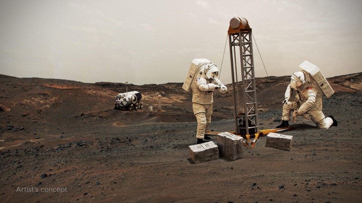
In this artist’s concept, NASA astronauts drill into the Martian subsurface. The agency has created new maps that show where ice is most likely to be easily accessible to future astronauts.
In this artist’s concept, NASA astronauts drill into the Martian subsurface. The agency has created new maps that show where ice is most likely to be easily accessible to future astronauts. NASA

Now, a NASA project called Subsurface Water Ice Mapping or SWIM has released a new set of Mars maps, showing the locations of subsurface ice. “If you send humans to Mars, you want to get them as close to the equator as you can,” said Sydney Do, SWIM project manager at NASA’s Jet Propulsion Laboratory, in a statement. “The less energy you have to expend on keeping astronauts and their supporting equipment warm, the more you have for other things they’ll need.”

Recommended Videos

Previous versions of the maps used a combination of data from various missions, combining data such as radar readings and indications of hydrogen. This allowed the researchers to locate the most likely areas of ice beneath the surface. The newest maps use high-resolution cameras on the orbiting Mars Reconnaissance Orbiter mission to look at regions where meteoroids had struck the planet and created impact craters that revealed the ice beneath, proving its presence.

Please enable Javascript to view this content

“These ice-revealing impacts provide a valuable form of ground truth in that they show us locations where the presence of ground ice is unequivocal,” said Gareth Morgan, SWIM’s co-lead at the Planetary Science Institute. “We can then use these locations to test that our mapping methods are sound.”
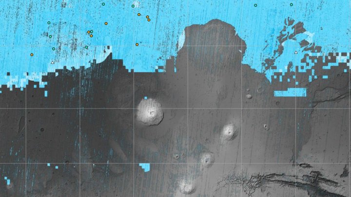
The blue areas on this map of Mars are regions where NASA missions have detected subsurface water ice (from the equator to 60 degrees north latitude).
The blue areas on this map of Mars are regions where NASA missions have detected subsurface water ice (from the equator to 60 degrees north latitude). Scientists can use the map – part of the Subsurface Water Ice Mapping project – to decide where the first astronauts to set foot on the Red Planet should land. NASA/JPL-Caltech/Planetary Science Institute

As well as being vital for future crewed missions, the presence of ice is relevant to the search for potential ancient life on the planet too. “In the harsh environment of the Martian surface, ice can act as a radiation shield. Biosignatures of past life in many ways are more susceptible to ionizing radiation damage than actual living organisms. So ice could preserve signatures of ancient life,” Morgan said. “Also if you can melt ice you have water of course, which is believed to be essential to life. So, in the very big picture, our maps will be of interest to exobiology studies.”

Georgina Torbet
Georgina has been the space writer at Digital Trends space writer for six years, covering human space exploration, planetary…
NASA’s Mars rover reveals what it’s grateful for this Thanksgiving
NASA's Curiosity rover on Mars.

It’s not just people who are sharing what they’re grateful for during Thanksgiving today -- Mars rovers are, too.

In a post on X, NASA’s Curiosity rover, which landed on Mars in 2012, shared a message saying: “These stunning views of the Red Planet are a reminder of how vast and mysterious our universe is. What are you grateful for this Thanksgiving?”

Read more
Check out this incredible panorama of Mars taken by Curiosity
NASA’s Curiosity captured this panorama using its Mastcam while heading west away from Gediz Vallis channel on Nov. 2, 2024, the 4,352nd Martian day, or sol, of the mission. The Mars rover’s tracks across the rocky terrain are visible at right.

The Curiosity rover has been on Mars since 2012, and in that time it has driven more than 20 miles -- which might not sound like a lot, but is a long distance for a rover traveling at slow, careful speeds that are somewhat less than the average garden snail. The rover has now reached the end of an area it has been exploring for the past year -- a channel called Gediz Vallis -- but before it moved on, the rover snapped a series of images of the area, which you can explore in this NASA panorama:

Curiosity Rover Leaves Gediz Vallis Channel (360 View)

Read more
Follow Mars rover’s 18-mile trip in NASA’s animated route map
The route taken on Mars by NASA's Perseverance rover.

NASA has shared a fascinating animation showing the route taken by the Perseverance rover on Mars since its arrival there in February 2021.

Perseverance is NASA’s most advanced Mars rover to date, and while its general routes are decided by a team at NASA’s Jet Propulsion Laboratory in Southern California, the rover actually moves forward autonomously, checking for hazards and moving around any problematic objects as it goes.

Read more