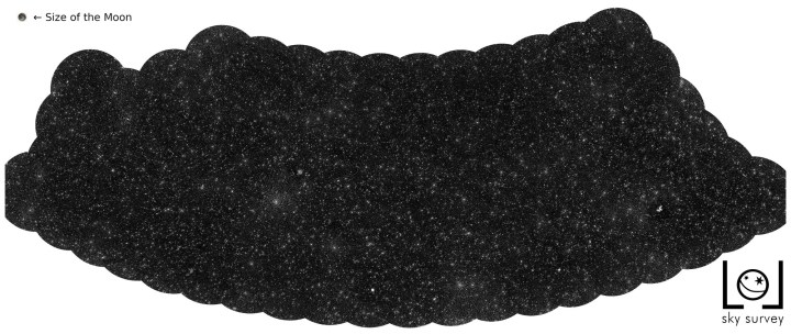
It might look like a map of stars, but that’s not what is shown in the image above. Instead, each dot on this map of the night sky represents an enormous black hole called a supermassive black hole, each in a different distant galaxy.
Astronomers know that at the heart of almost every galaxy (including our own) lies a monstrous black hole with a mass millions of times the mass of the sun. Black holes suck in everything around them and are so dense that nothing — not even light — can escape from them. However, it is still possible to observe them by looking at radio emissions. That’s how the famous first image of a black hole was captured in 2019.
A group of astronomers at Leiden University in The Netherlands used radio emissions to map out all the black holes that can be seen in a portion of the northern sky. They combined 256 hours of observations of the sky to spot the black holes.
But their task was complicated due to a shell of charged particles that surrounds the Earth, called the ionosphere, which distorts the incoming signals. “It’s similar to when you try to see the world while immersed in a swimming pool,” co-author Reinout van Weeren explained in a statement. “When you look up, the waves on the water of the pool deflect the light rays and distort the view.”
To adjust for this distortion, they created algorithms that were run on supercomputers to correct the ionosphere effect every four seconds. That allowed them to create the map above, which represents 4% of the northern sky.
“This is the result of many years of work on incredibly difficult data,” research leader Francesco de Gasperin said. “We had to invent new methods to convert the radio signals into images of the sky.”
The team hopes to continue the mapping project to cover the entire northern sky. For now, they are happy to have these results to share, as Scientific Director of the Leiden Observatory and senior author Huub Röttgering said: “After many years of software development, it is so wonderful to see that this has now really worked out.”


